An ancient earthquake that struck near Caboolture may yield some secrets to better prepare and respond to future strikes.
Moreton Bay Council is helping University of Melbourne researchers learn more about the magnitude 6.5-plus quake, which struck a fault line 20,000 to 35,000 years ago.
Mayor Peter Flannery says the study will help build a better picture of the damage that can result from a potential future earthquake and let them develop realistic response and recovery planning.
“Any project like this, where we can get a better understanding of the risks posed by potential disasters, is invaluable,” he says.
“It means we can not only better plan for the infrastructure needs of our community but work towards how we respond to a future event.”
Click here to visit Geoscience Australia’s earthquake monitoring web page
EARTHQUAKE LIDAR
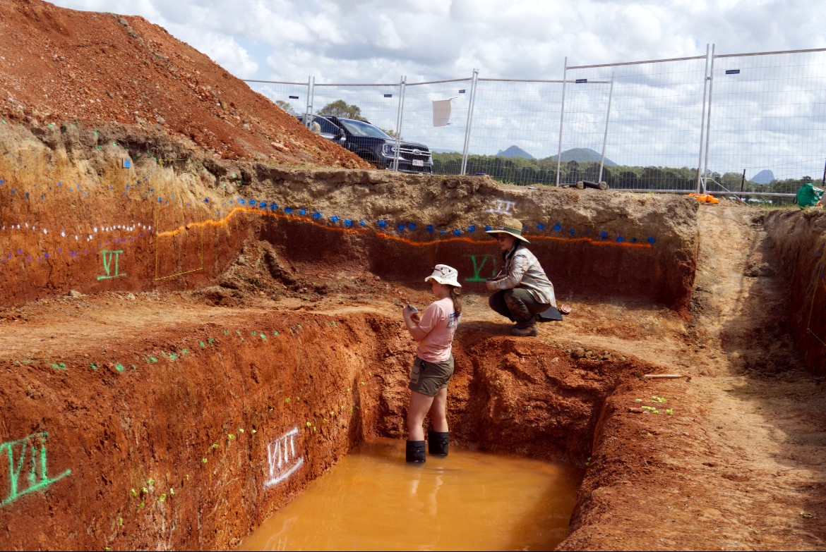
The Queensland-first project saw university researchers use Light Detection and Ranging (LiDAR or a laser sensing system) to map the location of past quake surface ruptures and the most likely locations of future ruptures.
Sediment samples were taken at different locations along a break in the ground caused by the earthquake (known as a scarp) late last year.
The university’s professor of earthquake science, Dr Mark Quigley says LiDAR allows them to scan the earth’s surface to identify signs of large, ancient earthquakes.
“Essentially, what we’re looking for are places where young sedimentary materials are broken by faults or pass across faults unbroken; we can use those to guide studies to determine the timing and the magnitude of past earthquakes,” he explains.
Dr Quigley said a second phase of the study involves analysing samples from the scarp which are currently being dated; the results will be compared to earlier LiDAR mapping findings.
“This is effectively geological detective work; we’re uncovering the mysteries of these past earthquakes,” Dr Quigley says.
“We dug a trench perpendicular to the trace of the fault in the landscape, digging down several metres. We then mapped what’s been broken by those earthquakes in terms of the faults and what passed through that fault zone unbroken.
“Through dating techniques, we’re then able to get a picture of when this earthquake roughly occurred, how big the magnitude was, and how much displacement occurred at this location.
“From that we can build scenarios around quake hazards for all sorts of end users.”
Moreton Bay councillor Matt Constance says any revelations could help ensure Council is thoroughly prepared for future ‘quakes which they can also share with other agencies.
“This really detailed and accurate data means we are better prepared.”
Unitywater and the Queensland Fire Department also helped fund the project.
While ‘quakes in Queensland are relatively uncommon compared to global standards, they are considered the state’s ninth natural hazard risk, council says.
MORE COUNCIL NEWS: Push on for state funding for roads