That was the assessment of Professor Emeritus David Karoly, a former author for the UN’s Intergovernmental Panel on Climate Change and internationally recognised for his work on climate.
Prof Karoly, former Fire and Rescue NSW commissioner Greg Mullins and NSW grazier Peter Lake were part of a briefing organised by the Climate Council and attended by NewsCop in the wake of Alfred.
“It is quite unusual for tropical cyclones to get as far south as Brisbane or northern NSW in terms of their impact,” Prof Karoly explains.
“This storm was not of record high intensity. It was category two but it was the first of these sort of tropical cyclones to affect Brisbane for more than 50 years,” he says.
“This is a rare event. That rare event also (came at) a time when there has been greater development in regions like the Sunshine Coast, Brisbane, Gold Coast and northern NSW; along the coast.”
Literally adding further fuel to the cyclone has been a 20cm-plus rise in sea levels over the last 50 years, fuelled by a warming planet,’ he says
“This storm has been stronger than other storms getting as far south because now many tropical cyclones, or in the Northern Hemisphere hurricanes, are penetrating further away from the tropics into the subtropics,” Prof Karoly points out.
“Ocean temperatures are warm enough to power the storms.”
GREG MULLINS
For former Fire and Rescue NSW boss Greg Mullins, the future is going to get warmer.
“The Royal Commission into National Natural Disaster Arrangements said that whatever we do now, there’s going to be some warming to mid-century. What happens after that depends on emissions reduction now,” he says.
Mullins says action is needed now to prevent the situation worsening or to at least stabilise it.
He refers to a recent litany of disasters, in Australia and worldwide, as “unnatural” especially compared to what he experienced in the first 30 years of his career.
“I don’t think they’re natural (disasters) because they’re nothing in like my early career. They’re just becoming more intense. They’re cumulative,” he says.
He cites the floods in Lismore in 2023, Black Summer bushfires (2019), Townsville floods (2018, 2022 and twice this year so far), bushfires in 2023 and 2024 and Tropical Cyclone Alfred.
“This was a major event but the big context here is it’s escalating,” Mullins says of the climate risk.
“We see it around the world with the winter fires in Los Angeles. I’ve worked there over the years; they don’t get fires after November but in January, they lost 18,000 homes, which is unbelievable.
“Maui, fires in Greece, Spanish floods there’s just this escalation because there’s so much more energy in the atmosphere. It drives extreme weather.”
ALFRED’S BIRTH
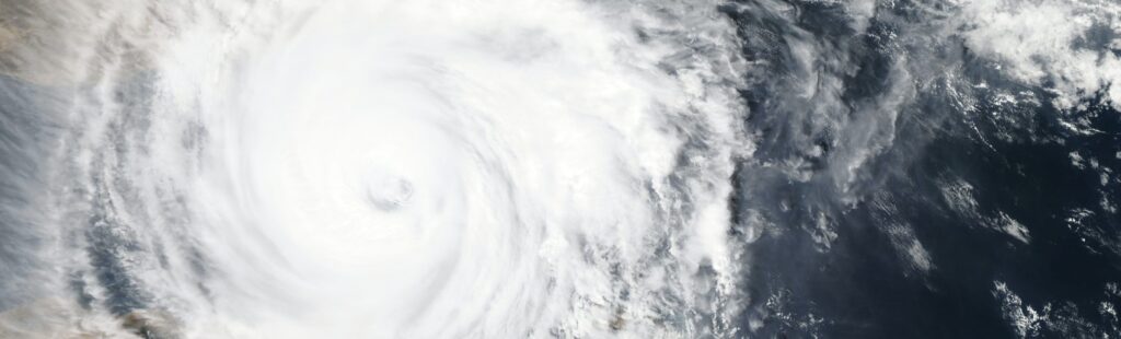
Prof. Karoly explains that Alfred formed in the Coral Sea (one of three around that time), where the ocean temperature is at least 26.5 degrees Celsius.
As it headed south, it intensified in strength due to record high ocean temperatures.
The biggest impact of tropical cyclones in terms of winds and rain are usually in bands of cloud and rain to the south of the cyclone’s centre.
As Alfred moved south, it picked up more moisture and dropped enormous amounts of rain as climate change driven warm ocean waters gave it more fuel.
CYCLONE’S PATH
Alfred formed over the Coral Sea about 1300km north of Brisbane on February 22. On February 27, it was Category 4 offshore from Mackay; at one point, Alfred co-existed in the South Pacific with two other tropical cyclones, Seru and Rae.
It tracked south for about a week as an offshore Category 2 storm.
While Coral Sea cyclones tend to be escorted east or south by cold air masses that steer them into the “cyclone graveyard” in the Tasman Sea, on March 4, Alfred made a sharp turn to the west, steered by a high-pressure ridge to the south.
On March 7, Alfred reached Brisbane’s offshore islands (Moreton, North Stradbroke and Bribie Islands) as a category one cyclone. The islands stalled the system and it weakened; wind gusts eased below cyclone intensity saving Brisbane from a much more intense storm.
Alfred made landfall on March 8; its path of destruction hit more than 600km of coastline, from Hervey Bay in the north to Coffs Harbour in northern NSW.
SOUTHERN ‘PUNCH’
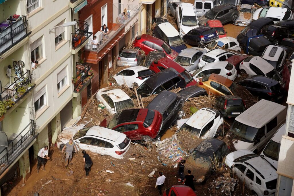
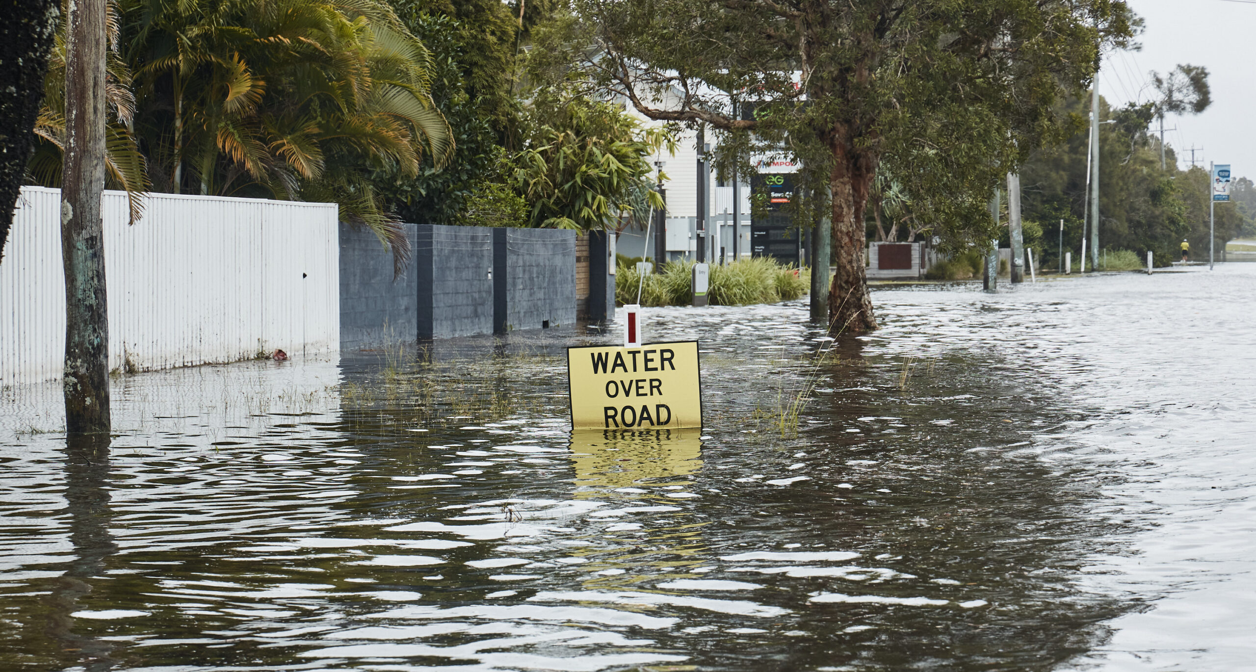
- Storm surges washed away beaches along 500km of coastline while the winds and extreme rainfall prompted the highest number of emergency call outs recorded in Queensland’s history.
- Communities impacted were as far north as Hervey Bay and as far south as Coffs Harbour (over 600km away).
- Storm surges on higher seas created damaging waves as tall as four-storeys. A 12.3 metre wave was the highest ever recorded on the Gold Coast. Beaches disappeared with sudden drops up to 6 metres high across new dunes at Surfers Paradise.
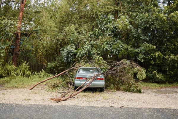
- Wind gusts of over 120kmh (in Byron Bay, NSW) and 107kmh (Gold Coast) ripped trees out of the ground, peeled roofs off and damaged property up and down the coast.
- Power lines were damaged as 500,000 properties across NSW and Queensland lost power; a record number for disaster-induced outages for Queensland.
- Rainfall: Brisbane recorded its wettest day in 50 years (since TC Wanda) with 275mm recorded overnight to March 10. Hervey Bay had its heaviest daily downpour in 70 years (more than 100mm in a single hour) while Nambour had its heaviest March rainfall in over a century (over 300mm).
- Qld’s SES fielded 3676 calls within 24 hours, a record for it.
- Energex says power restoration was needed for 500,000 properties with 9000km of line patrols, 1600 wires on the deck and thousands of responders over 11 days.
Sources: Climate Council
TOMORROW: NSW grazier tells politicians – walk your talk