
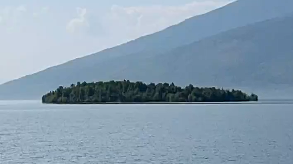
An island in a Canadian reservoir that went walkabout has been found again — about 30 kilometres away.
British-Columbia Hydro (BC Hydro) says the floating island, on Williston Reservoir, was found via satellite imagery, aircraft spotting and reports from boaters.
It says it is now resting against the shoreline of the Ospika Arm, northwest of where it was first spotted near Finlay Bay.
The good news is it moved further away from the reservoir’s WAC Bennett Dam and is not expected to affect operations, BC Hydro says
The utility’s community relations manager, Bob Gammer says the first reports they received of it on August 13 were treated with scepticism.
“When we first received photos and video of a floating island covered in trees, we weren’t entirely convinced,” he explains.
“In the age of AI, it’s important to verify unusual reports before drawing conclusions.
“Once we confirmed the island through satellite imagery and other observations, it quickly captured the imagination of the public and the media and sparked interest among scientists studying how floating vegetated islands form and move,” he says.
WILLISTON RESERVOIR: located near Mackenzie and 300km north of Prince George, it is the largest reservoir in British Columbia and the seventh largest in the world by volume. Created by the construction of the W.A.C. Bennett Dam on the Peace River, the reservoir began filling in 1968. The reservoir covers about 1773 square kilometres at full pool. Source: BC Hydro
TRACKING A MISSING ISLAND
BC Hydro says they were sent photos and video of the island believed to have been taken on or around July 21.
Last seen west of Finlay Bay, it disappeared and quickly sparked global media curiosity from the likes of BBC, New York Times, TMZ and National Geographic, the hydro authority says.
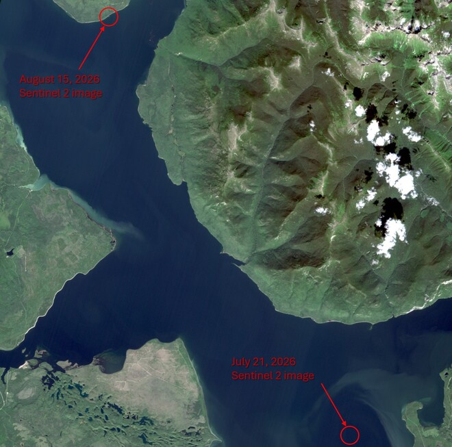
On August 31, BC Hydro confirmed its location using satellite imagery dated two weeks previously.
It says calculations show that it had drifted about 30km over 15 days then settled in its current location.
It appears intact and is estimated to be about 70 metres wide and 140 metres long with established vegetation growing on its surface.
HOW DOES AN ISLAND GO WALKABOUT?
BC Hydro explains that floating vegetated islands of this size are uncommon but can happen in large reservoirs.
It also offers one explanation: that it formed from logs and woody debris that accumulated in a sheltered area over time.
As the material gradually decomposed, vegetation may have taken root, creating a stable mass of interconnected debris and plant growth.
The hydro authority The island has also attracted interest from geologists, ecologists and other researchers interested in how floating vegetated islands form and move.
STAY OFF IT, SAYS BC HYDRO
While people are welcome to approach it by boat or drone to take photos, BC Hydro is asking everyone to stay off it.
It says the island is made up of logs and decaying woody debris which makes it unstable, and unsafe, to land on.
“Finding (it) has answered one question but it raised several others,” says Gammer.
“While we’re pleased to have confirmed (it’s) location, there is still more to learn about how it formed and how it came to drift across the reservoir.
We’ll continue monitoring the island and learning more about its origins and movement as the story unfolds. Stay tuned.”




