Image by Gianluca/pixabay.com
Severe Tropical Cyclone Alfred is likely to veer closer to the Queensland coastline in the next 24 hours with strong wind warnings and costal hazards in place.
And it could bring flooding to low-lying areas.
Senior meteorologist Angus Hines of the Bureau of Meterology (BoM) says TC Alfred is moving southwards at 9km/h in the Coral Sea about 700km east of Queensland.
“That will bring a significant increase in coastal hazards to parts of eastern Queensland,” he says.
“It’s estimated that the winds around Alfred at the moment are gusting around about 220km an hour … over these open waters.”
Hines says the bureau has already recorded gusts of around 70-80km/h for many coastal areas.
“Alfred is likely to veer closer to Queensland (over Friday and Saturday) and that distance is going to shrink … that could be down to around about 400km by Saturday afternoon,” he says.
COASTAL HAZARDS WARNING
The bureau has declared a coastal hazards warning for a stretch starting from near 1770, just south of Gladstone down to Coolangatta and taking in outer parts of Brisbane.
He says the warning covers damaging surf Alfred as well as abnormally high tides independent of the cyclone.
“(The impact will be) dangerous for coastal activities like rock fishing, swimming, surfing, boating; all of those things on and near the water become hazardous this weekend,” Hines says.
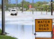
- “Inundation at high tide looks distinctly possible.”
Without Alfred, the coastline was already looking at close to the highest tides of the year.
“When you throw in the influence of the tropical cyclone, those tides could now be half a metre higher than the highest tides,” Hines says.
“That can lead to inundation, essentially flooding of low-lying coastal locations so things like walkways and car parks; (it) could also include a few low lying roads and properties.”
- Hines also cautions that the constant powerful waves will erode exposed coastlines, potentially eating away at beaches.
OUTLOOK
“The extended outlook into early next week will see Tropical Cyclone Alfred veer away from the coast out into open waters once again but likely stay as a category two cyclone,” Hines says.
“It’s unusual to see a category two cyclone in line with Brisbane. It does happen from time to time but certainly hasn’t happened in a few years.”
Alfred’s path next week, as of Wednesday, is more unpredictable, he says, but cautions that it could still return closer to southern Qld or northern NSW from Sunday with stronger wind, rain, large swells and coastal hazards.
Hines is urging residents to stay up-to-date with the BoM forecasts.